
Jul 6, 2010Precise GPS systems increase planting efficiency
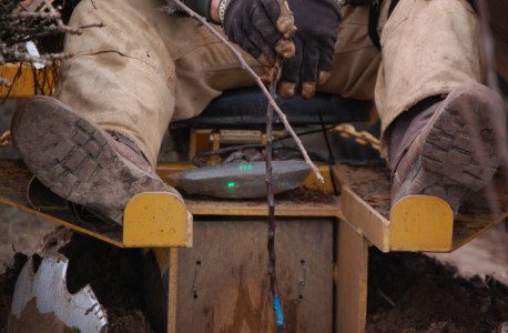
When the light turns green, plant the tree. Dave Alpers said this system will pay for itself within the first year. Photos by Derrek Sigler
By Derrek Sigler, Assistant Editor
When Dave Alpers from Redpath Orchards in Lake Leelanau, Mich., was thinking of planting a new block, he wondered how they'd go about setting it up with his water main. His son suggested he contact his friend, Phil Lucas at Voelker Implement Sales, and ask him about going to a GPS system. A couple of conversations later and they were all set.
"I look at what all I'm planting and how much time we'll save using the GPS systems; I figure the system will have paid for itself within the first year," Alpers said.
That is a pretty strong statement coming from Alpers, who has lived on and worked his orchards all of his life.
When global positioning systems (GPS) were introduced, it revolutionized personal navigation. Those first units were big, expensive and accuracy was measured in yards. Not anymore. Today, GPS is widespread. The cost varies according to use, but it can be reasonable – and in the applications used in agriculture, accuracy is now measured in inches or less.
"With GPS and the technologies applied from it, we're able to ignore the challenges of the terrain, the bumps, humps, hills and valleys," said Matt Rossow, a regional AMS specialist with John Deere's Greenstar division. "With what we have now, we are capable of being much more precise, down to the sub-inch."
Darwin Eisenga, who along with his brothers Bruce and Bryan owns Eisenga Potato Farms in Marion, Mich., has jumped onto the GPS wagon as well. They use a GPS system for planting potatoes and beans as well as alfalfa and grain crops. They too called on Phil Lucas.
"You get guys like Darwin who aren't afraid to look into the newest technologies; they are the main market driving GPS in farming," Lucas said. "Once they (the Eisengas) saw the amount of seed and, therefore, money they could save by not having the overlap on their rows like you often get when planting, it seemed like the best idea for them."
With any permanent crops, such as fruit trees or berry bushes, there has always been some sort of technology implied with the planting. Be it strings or even laser level lines, some sort of technology was involved in planting the rows to make a straight line. The limitation has always been terrain. Try to run a string through a hilly valley and you'll understand. It is difficult to be absolutely precise in terrain that isn't absolutely flat, and even then, the size of the area being planted can affect accuracy.
With Alpers at Redpath Orchards, they have incorporated two systems into one action. One GPS system navigates the tractor for precise rows and allowed them to navigate perfectly to align with the water main. That system reads out on a screen inside the cab of the tractor and keeps the tractor driving in perfect alignment with the preceding row and with the contour of the land.
The second GPS system ensures perfectly spaced trees. The block Alpers was planting on this particular day had trees with a 12-foot spacing. A GPS system read the exact spacing according to a grid system and read out on a light bar that was mounted to the planter. The worker riding on the planter was given a red light between the trees. A green light would flash with the red when the next location was coming and then a solid green light would flash when he was to plant the tree.
So, how are they able to be so accurate? It depends on the system being used and the manufacturer. In the case of John Deere, there are several forms of GPS available to growers and the difference is signal strength.
WAAS. The most common signal is Wide Area Augmentation System (WAAS), a government-sponsored differential correction signal with a static accuracy of approximately 30 inches. WAAS is a low-level accuracy signal, and is what is commonly acquired through handheld GPS navigation systems. WAAS pass-to-pass accuracy is plus or minus 18 inches.
WAAS operates using towers and satellites to distribute signal. When any of the towers need maintenance, the government shuts down the entire system.
SF1. SF1 is a single-frequency differential correction signal subscription available through John Deere. SF1, like WAAS, has a static accuracy of roughly 30 inches. There are, however, some significant advantages of SF1 over WAAS. The pass-to-pass accuracy of SF1 is plus or minus 13 inches.
SF1 uses two layers of towers and satellites to distribute signal. When maintenance is necessary on one layer of towers, the other set of towers acts as a backup; therefore, signal is always available.
SF2. SF2 is similar to SF1, but is a dual-frequency differential correction signal. SF2 has a static accuracy of approximately 10 inches. This accuracy makes it useful for more precise guidance applications such as automatic steering correction. The pass-to-pass accuracy of SF2 is plus or minus 4 inches.
"The Eisengas are using a system with the SF2 signal and a John Deere AutoTrac steering unit," Lucas said. "Once they set their rows, the unit actually drives the tractor and ensures precise navigation of the field and no overlap. Correcting the course is easy and ends up saving hundreds in wasted seed. If you were planting an 80-acre field and had an overlap of even one foot for every twenty-foot row, think of how much extra seed you've used when you're done? Add to that the time you save not planting the extra space."
RTK. Real Time Kinematic (RTK) is a technique used in land surveys and hydrographic surveys based on the use of carrier phase measurements of the different GPS signals. A single reference station provides the real-time corrections, providing accuracy to within the sub-inch.
In the field, RTK systems use a single base station receiver and a number of mobile units. The base station re-broadcasts the phase of the carrier that it measured, and the mobile units compare their own phase measurements with the ones received from the base station.
According to John Deere, RTK use is well suited to roles like planting blocks of fruit trees or fields of vegetables, although the parameters of the system limit the practicality of the RTK technique in terms of general navigation. In this case, the base station is located at a known surveyed location, often a benchmark, and the mobile units can then produce a highly accurate map by taking fixes relative to that point. RTK has also found uses in autodrive/autopilot systems and similar roles.
But GPS can do much more for your farm than simply guide equipment. Current technology allows GPS systems to work with other systems and tools to guide your information as well.
Jim Chambers, a business segment manager with John Deere's GreenStar division, said GPS could orient crews in the field and be used to track worker productivity, and even things like specific production, from a single tree or block.
"With things like PDAs and Smartphones, we can track productivity and movement in real time to optimize production and harvest," he said. "GPS is the basic tool to apply and use to the specific task we want to achieve."


Current Issue
On-farm AI: Water, farm, labor research guide decisions
Data collection tool expands farm management
Carmel Valley winegrapes: Parsonage Village Vineyard
IFTA Yakima Valley tour provides orchard insights
IFTA recognizes tree fruit honorees
Pennsylvania recognizes fruit industry professionals
Fresh Views 40 Under 40
see all current issue »