Weather data moves faster than it used to
Fruit Growers News asked agricultural weather experts about the changes they’ve seen over the last few decades. According to their comments, improved monitoring technology and information delivery have probably been the top trends.
Rodger Getz, president and CEO of AWIS Weather Services, Auburn, Alabama, has been studying agricultural meteorology since 1970. Back then, he said, agricultural weather services were almost exclusively provided by the National Weather Service (NWS), an agency of the U.S. government. For the most part, a private meteorological sector did not exist.
NWS provided farmers across the country with a basic weather forecast. It wasn’t very detailed, but attempted to focus on weather conditions in farming areas. The forecasts were usually carried by local farm broadcasters on radio and television. In selected areas of the country, however, NWS established ag meteorologist offices at land-grant universities. These one-person offices conducted research with local university faculty and issued daily weather advisories that provided the detail agricultural weather forecasts lacked, Getz said.
NWS maintained a “fairly robust” network of ag weather observation stations around the country, which provided essential climatology and forecast verification. Congress, however, abolished the NWS Agricultural Weather Services program in 1996. Today, agricultural weather services are provided by a handful of private companies, including AWIS Weather Services, which started when the NWS ag program ended, he said.
“The internet has changed everything by providing us with access to all the weather models, and a constant stream of weather observations, radar data and satellite information,” Getz said. “The problem is that it is a firehose of information that must be quality controlled and filtered.”
He said the primary goal these days is to predict things as far in advance as possible and get the information down to the field level as efficiently as possible. The end result allows growers to make better decisions, reduce costs and limit their impact on the environment.
“With the powerful computers that are available today, there are no limits to what we can provide for growers,” Getz said. “We can now deliver detailed, location-specific weather information directly to the grower. With recent improvements in rural communication, a grower can get instant weather alerts even while in the field.”
Jeff Andresen, Michigan State University (MSU) professor of geography and state climatologist, has been studying climate issues for a quarter century.
He said instrumentation technology has improved quite a bit in the last few decades: there are smaller, more accurate ways of measuring environmental variables than their used to be.
“Fifty years ago, we were still dealing with liquid and glass thermometers,” he said.
“Those still exist, but they’ve been replaced in many ways.”
Some variables – such as precipitation, which is difficult to measure – are still measured in traditional ways. But for most variables – relative humidity, for example – technology has made measurements cheaper and more accurate, Andresen said.
The biggest change might be the speed at which data moves from place to place. For a long time, data was largely read and written down manually. Today, data is collected, logged and stored digitally – and distributed almost instantaneously. Also, the computational power of devices is much greater than it was 50 years ago – and those devices can be held in your hand, he said.
Five decades ago, growers got their base weather information via newspaper, radio or television. But even though the ability to get base weather data quickly has improved by leaps and bounds, some farmers consider it information overload. They might have access to more information these days, but it’s hard to make sense of it all.
“Yes, more information is available, but we need more understanding of how to utilize the information,” Andresen said.
On top of that, the informational needs of fruit growers are more complicated than those of commodity growers – and the level of management is more intensive. Many growers are already stretched in terms of time and ability to manage information. They need help simplifying the data, or assistance making decisions. To do that, some growers hire consultants, he said.
“It’s not just technology that has changed,” Andresen said. “The user has to change, too.”
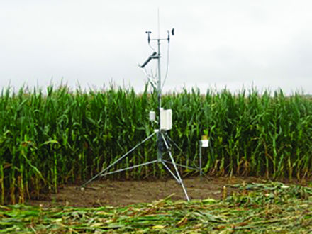
Today, Enviro-weather has 84 weather stations, 76 in Michigan and eight in Wisconsin. Photo: MSU
Dennis Todey, director of USDA’s Midwest Climate Hub, said that five decades ago, the standard temperature measurement was liquid in glass (mercury or alcohol). The thermometers were quite good, but they had to be read manually. Today, temperature sensors in multiple locations are connected via data logger and wireless communications to a computer, or even a phone. Data can be saved to a device and analyzed at any time. New measurement and computing systems notify growers when temperatures reach a critical stage or when an advisory is issued, he said.
“We still cannot provide all the specifics needed, but we can tell days in advance when a potential heat wave or cold outbreak is coming, and that additional management may be necessary,” Todey said. “And if growers are large enough, they can subscribe to specialized services that can give more detail than general forecasts.”
Enviro-weather
MSU’s Enviro-weather program is a good example of the evolution of ag weather monitoring. Enviro-weather was formed from the collaboration of two MSU programs: the Michigan Agricultural Weather Network (MAWN) and MSU’s Integrated Pest Management Program. MAWN consisted of a network of automated weather stations that collected weather data and transmitted it to a campus database, allowing users to view weather data and summaries online, Beth Bishop, Enviro-weather’s coordinator.By the mid-2000s, weather information was being used regularly in IPM management decisions, and there was a growing need for access to real-time weather data throughout Michigan. In fall 2005, MSU hosted a conference to discuss the use of technology for weather data collection and transmission, the uses of weather-based pest and crop management products and the delivery of weather-based information. Enviro-weather was formed in 2006 as a result of that conference, Bishop said.
When it started, Enviro-weather users could view data online from 42 weather stations. Today, Enviro-weather has 84 weather stations, 76 throughout Michigan and eight in Wisconsin’s Door Peninsula. And use of the program has increased each year. In 2007, Enviro-weather tools were accessed more than 39,000 times. By 2012, that number had increased to more than 200,000, according to Bishop.
Currently, Enviro-weather users can access 13 “general weather” tools – including weather summaries, degree-day maps and water-use tools – as well as 51 crop-specific tools: 24 for fruit crops, six for field crops, 11 for landscape and nursery crops and 10 for vegetable crops. And new tools are constantly being developed by MSU researchers, Bishop said.
— Matt Milkovich, managing editor